Sethusamudram

Introduction
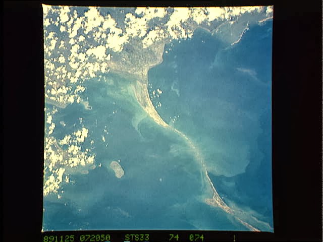
The above image are
the satellite photographs of the Palk Straight – The ocean passage between
South India and Sri lanka. The ocean floor here is shallow and is not navigable
and so no ships navigate via this region. All ships which want to move from
western world to the eastern world or vice versa via the Indian ocean currently
take a longer route of going around the country of srilanka. Even the ships of
India which have to move between the western and Indian coastlines of India
take this longer route of going around Srilanka.
The
Project
Now, the government of
India has come up with a project (in fact it is a project which was suggested
long back during the British age itself, but has reached the definitive stages
of implementation only now), called the SethuSamudram Project.
The intentions of the
project are good. To remove a silt of about 48 million cubic meters in the palk
straight at a cost of Rs 2,427 Crore (24,270 million), and create a channel 167
km long to make the sea in this region navigable. This will shorten the
distance between the east and west coasts by about 780 km for the ships! They
no longer will have to take the longer route around Srilanka. This will also be
a source of greater financial income to India as all international shipment now
can pass through the Indian seas in this region with the benefit of this
shorter distance, saving about 30 hours of time!
This new canal
construction is also said to increase the Naval security of India due to the
obvious reasons of making the connections between western and eastern naval
sectors of India shorter and easier and more importantly independent of
dependency on Srilanka!
Sethusamudram Canal History &
Facts


Hindus believe that the stretch of
limestone shoals between Dhanushkodi near Rameshwaram in Southern India and
Mannar in Northwest Sri Lanka are the remains of an ancient bridge built by
Lord Rama, as described in the holy epic, Ramayana.
Recent NASA satellite images show
clear pictures of a broken bridge under the ocean floor. The heritage of the
bridge and the story of Lord Rama are extremely sacred to Hindus.
The ocean floor between India and
Sri Lanka near the Mannar coast is very shallow and is not navigable. It does
not allow ships to pass. This means that. India does not have a continuous
navigational channel linking the east and west coasts. Ships coming from
India's west and heading to Bangladesh or Indian ports on the east coast have
to go around Sri Lanka because the waterway in the sea dividing the two
countries is shallow.
Therefore, the Government of India
has proposed the dredging of the sea to create a shipping canal to save up to
780 km of sailing distance and 30 hours of sailing time for ships plying
between the east and west coasts of India.
Indian officials say the canal,
which is called the Sethusamudram project, will also boost the national economy
besides speeding up the movement of Indian Navy and Coast Guard vessels as
well.
Hindu groups say this may be true
but such economic progress cannot be at the expense of Ram Sethu, as they refer
to Adam's Bridge, located at the southern end of the Sethusamudram project.
This is where an estimated 48
million cubic metres of silt will be removed over the next two years.
The construction of the canal
immediately led to wide protests in India by Hindu leaders. Several holy men
have gathered together to launch a campaign of protest.
In March 2007, over ten Hindu
umbrella organizations from around the world joined together to launch the Save
Ram Sethu Campaign (Ram SethuBachaoAndolan) to increase the profile of the
issue amongst the international communities.
The campaign hopes to convince the
Government of India to reconsider the construction of the canal as it will hurt
religious sentiments of millions of Hindus and also pose a great risk to the
environment of the region and the livelihood of local fishermen.
Ancient
India

Now a bit about
ancient India. The ancient Indian text Ramayana talks about a bridge being
built in the seas of Palk Straight by the then king Rama of North India who
wanted to take an army to the kingdom of Srilanka. This bridge is said to have
been built from Dhanushkodi, a place in South Indian coastal region near the
sea facing Srilanka, to Mannar in Srilanka.
Satellite
Photographs


The satellite photographs at the top of this article are of the Palk Straight. Clearly visible to a naked human eye
can be seen a line connecting the main land of India to Srilanka in these
photographs. This is exactly at the same place where Ramayana talks about a
bridge being constructed by Rama and his army to cross over into Srilanka. It
is visible from Dhanushkodi of India to Mannar in Northwest Srilanka and is
about 48 kilometers long.
Controversy
The Hindus call this
bridge Ram Sethu and is a sacred structure for them since it is mentioned in
their ancient texts. The proposed SethuSamudram project is going to destroy
this structure. It is a different question as to whether this is a man made or
god made or natural structure. (Well, for a hindu everything natural is God
made!). The issue here is that this project in its current proposed format is
definitely going to destroy this structure. The controversy is that do we need
to have economic progress at the cost of our cultural heritage? In this
materialistic world some people might look at everything in terms of money. But
the spiritual center of the world, the Indian masses don’t look at it that way.
Let me make it clear,
it is totally a different question as to whether this bridge is man made or is
it a natural formation, the answer for that question has to come from a
thorough unbiased scientific investigation by a committee of national and
international experts on the subject. The need to save this structure is that
it has been mentioned in the ancient texts and hence definitely is of a
cultural value and has historical significance.
Man
made or Natural?
Before going deep into
any related scientific evidence of whether it is man made or natural, let us
see what common sense says. Can a natural formation so precise as 100 m occur
all across the way from Indian to srilankan coast line? Is there any other such
geological landmark on this planet? How did this happen? What is the scientific
evidence for a natural formation like this?
Or if it is not
natural, then what is the scientific evidence that this is a man made
construction? If it is mad made, then the material which this bridge is made up
of should not have its origin in the seas.
Here is what the Department of Earth Science of the Government
of India has to say about it
The Geological logging of the bore holes drilled in the inter tidal areas of Ram Sethu reveals very interesting details. In all the bore holes the top portion is seen to be occupied by recent marine sands. In almost of all the boreholes between 4.5 and 7.5m the borehole intersected hard formations, which have been found to be calcareous sand stones and corals. It is to be pointed out here that Corals are comparatively less dense, compact and somewhat easy to carry.
The Geological logging of the bore holes drilled in the inter tidal areas of Ram Sethu reveals very interesting details. In all the bore holes the top portion is seen to be occupied by recent marine sands. In almost of all the boreholes between 4.5 and 7.5m the borehole intersected hard formations, which have been found to be calcareous sand stones and corals. It is to be pointed out here that Corals are comparatively less dense, compact and somewhat easy to carry.
The Corals normally grow atop compact to hard formations for the
purpose of stability, and as the sea level rises, the Coral colony grows up
vertically to maintain water depth of 1 to 2 m, which is essential for their
survival. In the case of Ram Sethu area, we observe that the Coral formations
hardly occur 1 to 2.5m in length and resting on loose marine sands. Most of
these coral rock pieces are seem to be rounded pebbles of corals. These things
appear to point these coral rock pieces and pebbles have been transported and
placed in these areas. Since the calcareous sand stones and Corals are less
dense than normal hard rock and quite compact, probably these were used by the
ancients to form a connecting link to Sri Lanka, on the higher elevations of
the Ram Sethu ridge and this is analogous to modern day causeway.
In support of these observations there are many archaeological
and geoarchaeological evidences on the south east coast of India around
Rameswaram, Tuticorin and the western coast of Sri Lanka. There are raised Teri
formations that supported a rich assemblage of mesolithicmicrolithic tools
indicating the presence of strong human habitation and activity in these areas
as early as 6000 to 7000 years BCE and as recent as 2000 years BCE. On Sri
Lanka side there are indications of human habitation extending to late
Pleistocene (about 11,000 BCE) based on bone and fossils of human and animal
form. All these point to a flourishing human activity on both side of Adams
Bridge and probably when the sea levels were just right the link between India
and Sri Lanka could have been established.
Arguments
The very first
argument in favor of a man made bridge is the ancient references to this
structure in the ancient texts of India.
Then comes the nature
of the structure. Can natural accumulation be so precise? Look at the
photograph again. It defies common sense to say it is natural unless and until
one is extremely biased for whatever reasons OR unless one provides a very
concrete scientific evidence of how it occurred. Not just use some
pseudo-scientific language like It is natural sand and coral formation. From
where, why so precise? Did the corals decide to build a bridge?
Some people argue that
it is not a real bridge. Well, yes, nobody is saying that Rama had built a
concrete bridge like we build today, a real motor-able bridge with supporting
pillars etc. Even ancients texts say that this bridge was built using sand and
rock boulders! Rocks from the mountains were transported to the construction
site using machines says the original text valmikiramayana
Hastimaatraanmahaakaayaahpaashaanaamshachamahaabalaahparvataamshchasamutpaatyayantraihparivahanti
cha 2-22-58, Valmiki
Ramayana
which means Vaanara with huge bodies and mighty strength uprooted the elephant sized rocks and mountains and transported them using machinery!
which means Vaanara with huge bodies and mighty strength uprooted the elephant sized rocks and mountains and transported them using machinery!
Let me be frank. Till
I saw this photograph and realized that this was a shallow sea between India
and Srilanka where Rama is said to have built the bridge, I was thinking that
the bridge is actually a myth. My thought was how can once construct a bridge
across a sea by a few thousand people throwing sand and rock boulders into the
sea water?
But now on looking at
the photograph and realizing that it is a shallow sea and not a narrow
straight, it doesn’t really seem like an impossible task to do one such
construction. Note that as per the ancient texts, the bridge was said to have
been built not as a permanent structure to connect the two lands, but only to
serve one single two-way journey for an invading army from India into Srilanka.
Some people say that
the ancient Indian texts are nothing but a mythology. Well, anybody who says
this I must say, either
- has not read these ancient Indian texts (look at some of the scientific explanations in these ancient texts in other parts of this blog) OR
- is totally prejudiced in believing what he believes than in what it is OR
- has no general knowledge and is not aware about the recent archaeological findings. For instance, earlier they thought the story in Mahabharatha of Dwaraka being flooded by the seas after the war was a myth, until the ancient city of Dwaraka was found submerged in the seas of Gujarat. They used to say that the river Saraswathi mentioned in these ancient texts was a myth, unless dried up river bed of this river was discovered in North India.
My question is what if
we today destroy this Ram Sethu, the bridge, and then tomorrow find a proof
that this was indeed a man made construction? Will we get back the bridge, by
paying all the money that India has earned by destroying this bridge? Can the
lost heritage be brought back?
According to one Oceanographer, the construction of the
SethuSamudram Channel may also increase the risk of tsunamis on the coasts of
South India as this shallow water has been protecting the calm sea on this side
of the Gulf of Mannar from the wild sea of Bay of Bengal! See this article .
Another issue is that
the world’s 30% Thorium reserves are found in the coasts of Kerala. Exposing
the Kerala coastline to the rough sea will wash away most of this Thorium into
the sea! The fast breeder Thorium based nuclear reactors that Indian scientists
are trying to build are based on the fact that we have these large deposits of
Thorium which we can use to remove our dependency on other countries like USA
and Austrialia for nuclear fuel like Uranium to our nuclear reactors. What will
be the result if this monumental blunder project washes away all our Thorium
reserves? Will the project be an economic gain then? Even if the Thorium
deposits don’t get washed away immediately, the next tsunami in this region
will definitely take most Thorium with it into the sea!
It has to be noted
that this narrow straight and shallow waters and Ram Sethu is what saved the
shores of Kerala from a major disaster during the December 2004 Tsunami!
Awareness

It is interesting to
observe that be it Ram Sethu, or the Dwaraka in the seas, etc it is always that
the western science, researchers, archaelogists, etc that have been telling the
Indians, see here, you have a great tradition, science and culture. The
government of India or Indians have done very little to dig into our past
history and culture. Forget even structures outside the mainland, there are
still numerous un-excavated territories in the main land of India itself! If
not for the NASA satellite photographs, the SethuSamudram channel would have
been built, without us even being aware about the destruction of this structure
nor the existence of it!
No comments:
Post a Comment